Sunday, 2 October 2011

The Melbourne Walk


MELBOURNE WALK
Thursday 29th September 2011

The walk was described as ‘A lovely relaxing walk through the rolling South Derbyshire countryside ..’

The weather was spectacular, for any time of year, with totally blue skies and the temperature that would reach 28 C. But, it was especially out of character for late September.

Not being very far away and not much of a detour to stop off at Willowcroft Care Home to pick up the last of Margaret Cornish’s mail, we set off along the A52 towards Spondon. It was also a good opportunity to pick up some bits at B & Q. In the car park at the DIY store was parked a very pretty pink car and so this was the first subject of the photographic journey. The reason for this was that Zoe, our oldest NZ granddaughter likes pink cars. (They are unusual.)

Pink Car for Zoe

Following directions from there on the SATNav we parked on a street in Melbourne within site of the church. Our walk direction said that the walk would start between the Parish Church of St. Michael’s and Melbourne Hall; both described as ‘two of the counties gems’. We were in the right place to start the walk. Unfortunately, one of the county’s gems was surrounded by scaffolding and thoroughly tented in.

Garden shop
The yard with its craft shops and toilets was open and this was our first stop. I inadvertently gave Irene the idea that we would not start with our usual refreshments. So, through the gateway into the beginning of the Melbourne Parks. This was a nice gentle start around ‘Melbourne Pool’. It was infested with its usual gaggle of Canada Geese. 

Melbourne Pool
The first field, or so, was quite gentle and the paths well marked. On we plodded looking for the six steps down to take us to a stile.

At this point I became aware of a veritable army of brightly coloured army in procession behind us.

The Colourful Army
It was time to give them the slip. This I did by continuing to walk the path at the edge of the field until it came to a dead end. By the time we got back to the six, well disguised steps, leading to the, clearly marked post by style, the army had already found the correct path and were well ahead of us.


They Weren't Able See Us
Here the walk began to go up hill; at first along a grassy lane. (Did I say that it was now 28 C and there was no shade, even on this lane?) It was not long before it was time to leave the lane. The post came in site, but where was the path? The guide said to go left. The yellow arrow pointed left. But where was the path. A little bit of scouting showed evidence of trainer print in the dust. I believe the dust is what we call soil. And so, in the way of ‘Good King Wencelas’, we did trot. This was to be the first of number of fields lacking a clear path and going steeply up hill. It became obvious that the farmers had recently ploughed their fields and seeded them. But the lack of water meant that the path way was not being trodden out and that rapidly shoe prints had dusted over.


Mark My Footsteps
We plodded on though a small wood, but swarming in insects. And, becoming quite weary we needed shade and a place to sit. Having gotten over the top of another dusty hill, with a good view of Breedon church our only option was a shade-less path of grass on which to sit and consume our picnic. With hindsight and knowledge that farmers generally do not put out shady picnic tables in their fields, we knew that the logs in the wood would have been a better option. But hindsight does not inspire anyone to back track up and over a dusty, sun baked hill.

The Plough
On we plodded along an easier walk, along a lane with some shade, past Breedon Golf Club and into the village of Wilson. Carefully hidden was the entrance to the next section of uphill sun-baked trackless waste. In this field we trod on pea seedlings trying to sprout out of the dry earth. How they are growing is a miracle. The only shady log to sit on was a waterless oasis fifteen yards off the path. Re-finding the path proved more difficult than finding it by looking along it at the start.


The Pea Path
From the top was a clear view of Melbourne and the path downhill was like a grassy piece of park land and, it seemed unexpectedly, we were back by the pond. Refreshments were desperately needed, but shade was still denied us.

Finally it was a visit to the ‘Tree Tops Hospice’ charity shop. Mum though she might find something useful. But it was me who bought a Cussler book for 50p before to the car and home we went.


There was a little time to spare and so we went to visit the gem that is St Michael's church. We had a good conversation with a lady attending to the flower arrangements and I took one or two photos.


We had not intended to do the walk. It was worth doing. It could not be any stretch of the imagination be described as relaxing. Certainly, it was lovely.

Our next sortie is to be to simply go somewhere and without an assault course map. 

Saturday, 24 September 2011

Straws Bridge and the Nutbrook Trail


Bottle Kiln

It was a beautiful, warm, sunny morning. We started our journey at the 'Bottle Kiln'. This is a tastefully laid out gift shop to the west of Ilkeston with its own restaurant. (http://bottlekiln.co.uk/index2.html) The shop areas could be described as being cluttered, but elegantly done.
Christmas Decorations
 Some of the art work was a bit over priced, but then you could be the unique owner of some unknown artist for £495. The restaurant area was fitted out very tastefully and it would seem that they would take special dietary requests, particularly if dairy-free is asked for.
Coffee Art

Straws Bridge
We back tracked to Straws Bridge pond car park. This was large and free and edged right up to the pond, which was had a large number of water birds enjoying the titbits from the human visitors.
Heron Spied onWalk

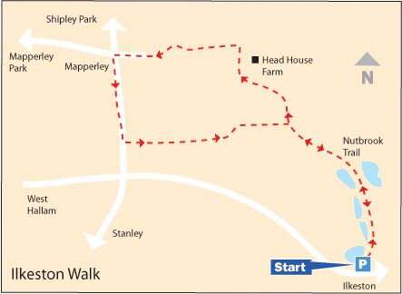
Then we started the walk.It was disastrously documented from the start, but we did use our common sense and find the beginning of it. The trail (on old railway line) followed the Nut Brook and passed other lakes.

Following the instruction we turned off the trail, which was then a path which went on and on without us finding any more confirming landmarks. At last we arrived at the road into Mapperley village, where we discovered that we were going the wrong way around the loop. Just before we reached the village there was a welcome bench which gave us a stop for lunch.

The Trail Map
Back tracking proved equally difficult and we never approached anywhere near 'Head House Farm' that it ever could have been a useful landmark. At one point we were fortunate enough to find an 'electric style', but even then the best we could do was exit the field by climbing over the gate.

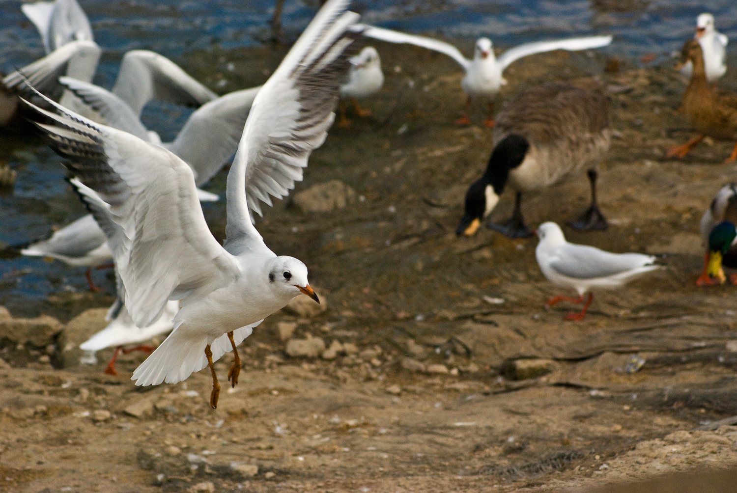
Feeding Frenzy
 Eventually we got back to the car to find a feeding frenzy of birds, before we set off back home.

Thursday, 22 September 2011

Hall Porch Complete

Today members of the New Stapleford Association committee completed the porch for the rear entrance of the hall. 
David removing frame nuts
The base and the frame work and the roof were built by tradesmen. Over time we have boarded up the structure and David built the very professional looking window frames. All this was painted in readiness to fit the plastic glazing sheets. After one hours work this morning the structure was complete.
Alan securing the final frame

Wednesday, 21 September 2011

McArthurGlen

Totem


Shoe shopping day. Not me; mum.
The Glen
McArthurGlen is a designer outlet which is off the second junction from where we join the M1 at junction 26. Irene needs wider fitting shoes and the 'Clarks' shop sells a good choice of shoes at a reasonable price. During her browsing time I made a visit to the 'Works' outlet. Later we bought items there for various presents.

After Clarks the next activity was coffee and cake. They have a large food hall which consists of a lot of seating surrounded by various food outlets. We found a good coffee shop with a chatty 'barista'. We were attracted to the availability chai latte. (http://en.wikipedia.org/wiki/Masala_chai). Unfortunately, they only had enough to serve one. By way of compensation mine had coffee art. According to their literature 'A well trained barista will always give you latte art on your coffee. It is a sign that they know their craft.'
Coffee Art by a Well Trained Barista
After coffee Irene fulfilled her wish to look in another shoe shop. This was called 'Pavers', and had an even better selection of suitable shoes than 'Clarks'. I will refrain from commenting on the outcome.

In 'Pavers'
On the way home we called into B & Q to purchase garage floor paint before returning home for lunch and more garage painting

Monday, 19 September 2011

Anniversary Walk


24th August – Longnor

Panorama Looking Over the Valley
 This was our anniversary walk. The main aim was to have a meal out. Joni was on holiday and accompanied us on the walk. Getting to Longnor and the start of the walk proved a little irksome. Firstly, the SATNav refused to cooperate for some time. I did not do too badly navigating from memory. (We are gradually putting together the various part of Derbyshire on our mental map.) Secondly, we arrived within just about a mile of our destination when right in front of us was a detour sign at a cross roads. There was no instruction about whether to go right or left. After some thought and two different pieces of advice; one from Joni’s mobile to go in one direction and the other from Irene’s paper technology to go the other. I elected to go left. Now, instinct cut in. I correctly anticipated coming upon a further cross roads, and just as correctly anticipate that the SATNav would direct a left turn back to the road that we came in on. I turned right. Instantly the instrument added 25 minutes to our eta. Were we really on a road? Or where we on a very rough switch back going one way?

At last we reach Longnor. I am told that the route taken was through spectacular scenery. I have to say that gritting teeth and focusing all attention on staying on the road before had the effect of blinkering me from such picturesque countryside. Road side parking was free and near an interesting cafe and near to ‘The Old Cheshire Cheese’, which was to the place for our midday meal. After the usual the challenge was to find the start of the walk. This was to be the worst ‘walk-start’ location that we have had. The start was the Market Square, were we where. The direction was to go towards Crowdicote, which we did. We were to go left down Doveridge; which we could not find as the only road going left had a totally different name. So, back we went and found a different part of Doveridge. Long story, but an olde villager put us on something like the correct route. Across the valley, following our directions we did go.
Distinctive Hill Shapes
Exciting Clouds

 Then came the farm on our left (no right). Not that it mattered in that there was no way to pass the guard dogs in the farmyard. (Can you blame the walk author for this difficulty?) So, half an hour was added. By the time we reached Crowdicote we had had enough walking and decided that the short cut back to Longnor and the pub was the best option.
Crowdicote Showing Evidence of Road Closure
Joni Photographing Cows
 We had an excellent meal in great surroundings. (Sounds like an advert.) A feature of the pub was that small historical bits were displayed in a table cabinet beneath the glass table top. There were items such as a receipt for a “Milbro” Waterless Cooker from M. Rossetti, London S.W.5; described on the document as a Gass stove, costing £5.19.6 and delivered free of charge, C.O.D.
Table Display
The Receipt
My Steak
Irene's Lasagne
The main feature of this walk was that we were near the sources of the River Dove and the River Manifold, which run parallel at this part of the world.

Sunday, 18 September 2011

Last Blog 2nd August

Last blog 2/8/11

I have certainly missed out on blogging for a long time. It is an activity that I quite enjoy and it might be a useful way to remember some of the lessons learned in previous years. Learning is, for me a very important activity and, these days, more important than teaching. After all, who wants to take any notice of a grumpy old man, who is entrenched in the philosophy of the good old days.

My poor blogging record lies in the slowness by which I prepare the images from the raw camera data.
However, here goes. Well nearly. I am reflecting on a comment that my photography aims for technical perfection, but is a ‘were I’ve been’ genre. I am considering a portfolio called ‘The Best of ‘Where I’ve Been’’. Hoping I have the correct collection of apostrophe/quotation marks. Perhaps I would better to format it to “The Best of ‘Where I’ve Been’”. Still looks ugly.

23rd July - Cossall and the Nottingham Canal


This was the day that we discovered a magical world on our doorstep. Just 10 minutes drive from here is a car park near the village of Cossall. From the car park; alongside the disused Nottingham Canal is an easy walk. At each boundary along the walk the canal changes its character in a very clear way. There was a great deal of colour along the walk, wild life, industrial archaeology; although the town of Ilkeston was only a few fields away. The down side was that there were no cafes or toilets. The latter made for an interesting challenge of finding a secluded spot.

Disused railway viaduct
Heron taking flight
Bull rushes

28th July - Dale Abbey and Stanton Hall
This was my first visit to Margaret Cornish in her new care home. We decided to combine the visit with a quick walk in Dale Abbey. We have never seen the ground so dry. Most any other time we have been there has been some mud somewhere. Today the driest areas had turned to sand. However even the dry ground did not deter an odd frog from crossing our path.
Frog
Path

Margaret is now resident in Stanton Hall, which is a large house standing in its own grounds.
Stanton Hall
  3rd August - Millers Dale

This must have been one of the best days of the summer. We headed to Millers Dale with a view to walking along the River Wye to Litton Mill. It was one of the few times this year that we have paid to park. At least there was toilet stop at the start, but no nearby tea room. The walk goes over one of two massive viaducts over the Wye, along the old track bed before dropping down the bank, across the Wye (http://www.derbyshireuk.net/river_wye.html) to Litton Mill. I had visited this area some years before with a school party. At that time we were walking in the much seasonal Peak District rain and we sheltered in a dilapidated building at this spot. Now the buildings have been converted into luxury apartments and holiday homes.

Litton Mill Apartments
Cressbrook Mill and Mill Pond
Sluice Control
Mill Pond Outflow
We arrived at the Mill to find that here the developers had taken over and the refreshment rooms had been closed and looked very dilapidated even though it was not so long ago since our first visit to Monsall Dale. So, we scrambled up to look over Monsall Dale to have the picnic that we are now in the habit of carrying.

Our final stop before the car was ‘The Anglers Rest’ which is charming and close by the river. Here Irene encountered Crabbies alcoholic ginger beer for the first time and enjoyed it. From here it was quite a struggle to climb back up to the main track back to the station.


We did conclude that the map and walk directions for this walk were pretty good.

17th August – Illam 

This walk day was almost as bright a day as the last one and the walk was superb. The writer of the walk was once more accurate in the write up and the map. Unsure of the area and having parked for free on the road side we wondered off towards Ilam Hall (http://peakdistrict.nationaltrust.org.uk/ilam-hall).This turned out to be a good decision. The hall is now a youth hostel in a stately house building in a wonderful park. Refreshment were good and a good value which we took on the terrace overlooking the hill around the River Dove.
Tea on the Terrace

A View From the Terrace
We walked past the cottages modelled after Swiss cottages. Apparently, a former owner of the hall was so impressed by his visit to Switzerland that he had the buildings visible from the hall demolished and replaced by Swiss style buildings.


Swiss Style Cottages

 The walk took us over fields towards the Dove Dale car park. There was a slight difference between the instructions and the walk. But, this was not serious.

When we arrived at the river we realised that this was truly the Summer holidays. Cars were queuing to get in and we were in crowds headed towards the stepping stones were we had to queue to cross.

Stepping Stones Over the Dove
On our two previous visits, out of school holidays we practically had the place to ourselves. We had thought to have our picnic and return from there, but we had made good time and decided to complete the walk. Fortunately, after crossing the Dove our route took us away from the crowds, around the back of Thorpe Cloud. This meant walking from the confluence of the River Lynn and the River Dove up to the source of the smaller river. Here we found a small cave. Below the cave the ground was deeper green with water plants. Above the cave the ground was the usual moor land. This must be one of the smallest rivers as we could see the end from the beginning. (A bit God-like.)

We were not very clear about the path at the top and kept more to the right of the field than we should have done. We found a nice spot to sit and picnic before going on to the village of Thorpe and a convenient toilet stop.

Picturesque Cottages in Thorpe
 The route took us through the village and down a farm track with a surprise at the bottom of a major road bridge. We found out that a road had been built to go through to Leek, but then it was discovered that the cars of the time would not have the power to climb the incline to Thorpe.

Abandoned Road Bridge
Having crossed the River Manifold the path, sadly, took us away from the river and at one point the path would have disappeared if it had not have been for a brightly coloured, tall way marker. From here it was an easy walk down and along the river back to the car.